


Shorouk Express
For free real time breaking news alerts sent straight to your inbox sign up to our breaking news emails
Sign up to our free breaking news emails
Sign up to our free breaking news emails

The Met Office has issued a thunderstorm warning in parts of England and Wales as the UK braces for a weekend washout.
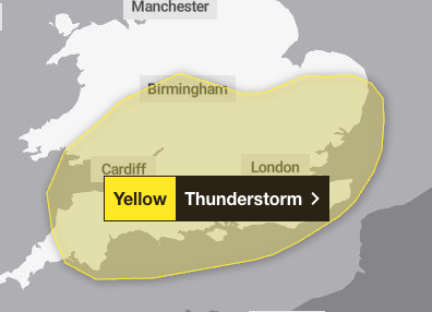
The yellow weather warning on Saturday covers southern England, parts of the midlands, London, east England and south Wales.
Frequent heavy showers and thunderstorms are expected for much of Saturday, before fading from the west during the mid to late afternoon.
The Met Office warned 10-15 mm of rain could fall in less than an hour, whilst some places could see 30-40 mm of rain over several hours from successive showers and thunderstorms.
The storm could also bring lightning, hail and strong, gusty winds which will cause additional hazards.
open image in gallery
Delays to public transport including buses and trains is expected and driving conditions could also be affected by spray and standing water leading to longer journey times.
Damage to buildings from lightening strikes and short term loss of power is also likely, the Met Office warned.
Temperatures are also set to drop on Saturday with lows of 10C expected in London and 7C forecast in Glasgow.
The stormy weekend comes after Britain saw the sunniest and warmest start to spring on record and the driest spring in over a century.
More than 600 hours of sunshine were clocked up across the country between March 1 and May 27.
Despite the predicted wash out weekend the Met Office’s three-month outlook predicts that the chance of a hot summer is higher than normal, bringing an increased risk of heatwaves and heat-related impacts.
The outlook shows it is 2.3 times more likely than normal that the UK will be hot over meteorological summer, which begins on 1 June and ends on 31 August.
The average temperatures across the UK over those months range from 10-17C, with the south east of England experiencing the higher averages of 16-17C.


